


The redevelopment of Ladywood raises critical questions about urban density and the sustainability of community living, writes Joe Holyoak
I wrote in a previous column about the contest that often exists between housing density and the provision of public open space. I cited the case of the Birmingham inner-city neighbourhood of Ladywood. There, the residential density before the ruthless modernist comprehensive redevelopment of the 1950s and 60s was 65 dwellings per hectare (dph), made up entirely of two- and three-storey terraced houses. Following the redevelopment, which included seven 12- and 15-storey tower blocks, the density was reduced to 33 dph. Half the population had been relocated elsewhere.
Since that column was written, the Preferred Options Document of the new Birmingham Local Plan has been published for public consultation. It contains proposals for significant increases in housing density. Previously, the minimum figures for new residential developments were 100 dph in the city centre, 50 dph in local centres and areas well served by public transport, and 40 dph elsewhere. Historically, Birmingham has been suspicious of high densities and has favoured low-density developments. This is now changing due to pressures to house a growing population and to meet standards of sustainable development.
The new minimum figures proposed in the Local Plan represent a quadrupling of the previous minimum figure for the city centre to 400 dph, 70 dph in local centres, and 40 dph elsewhere. This represents a colossal increase in housing density in the city centre, including Ladywood. Two issues arise from this: the consequences of the specified density for urban form and character, and the issue of credible public consultation on planning strategy.
To take the second issue first: planning – its purpose, how it is done, and who does it – is little understood by the lay public. Planning would improve with more active democratic engagement. But is the public itself to blame for being poorly informed? If not, who should be responsible for educating them about planning: schools, local planning authorities, social media? Specifically addressing the 400 dph proposal, I doubt that most people even know what a hectare is. Furthermore, I suspect that fewer than 1% of people have any idea what a neighbourhood built at 400 dph looks like. So, there is little point in asking them. A cynic might argue that such ignorance benefits the planning authority in pushing through its proposals.
In preparing the new density figures, planning officers researched and produced a background paper on housing densities, which is published on the council website alongside the draft Local Plan. However, it is unlikely that many respondents ventured far enough to study it. Sixteen city centre developments approved between 2017 and 2021 were examined, and their statistics documented. Their densities range from 50 to 2,170 dph, with an average density of 358 dph. This is quite close to the new 400 dph figure.
However, the similarity is misleading. Many of the higher-density developments consist of one or more tall buildings on a small site (the average site area is 0.16 hectares). They are an exception to the less dense fabric that surrounds them. The mistake planners have made in their analysis is to imagine that this exceptional mode of development could feasibly be extrapolated to cover a whole area. It couldn’t: the result would be almost uninhabitable, akin to some of the denser, though not the densest, parts of Hong Kong.
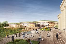
This is particularly relevant to Ladywood. The inhabitants of Ladywood are facing a future in which 60 hectares of their neighbourhood will be “regenerated” (meaning redeveloped) by a partnership between the city council and Berkeley Homes, the council’s preferred developer. This will entail considerable densification. There is, as yet, no agreed masterplan for the redevelopment. To calculate a tender price for the contract, Berkeley apparently created a notional masterplan that generated a figure of 7,531 dwellings within the 60 hectares. This figure, produced without any involvement from residents, is now being used by the city council as the target for the “regeneration”.
>> Also read: Birmingham used to know how to undertake community partnerships. It needs to relearn… quickly
This figure represents a residential density of 125 dph. However, if the council’s criteria for public open space, new schools, a local centre, and other non-residential uses are factored in, the proportion of residential land within the 60 hectares is likely reduced to 50%, yielding a net residential density of 251 dph. This is high, and when I met with the council’s Director of Planning in 2023, he agreed it might be unachievable. Nevertheless, this figure is nowhere near the 400 dph minimum density proposed in the Local Plan.
The contract between the city council and Berkeley Homes is yet to be signed. However, the council’s mishandling of the project so far has caused significant distress and anxiety among Ladywood residents. The main fear is widespread demolition of existing dwellings, reminiscent of the comprehensive redevelopment of the 1950s and 60s. This fear spans owner-occupiers, leaseholders, and council tenants. A Cabinet report on the Ladywood regeneration in 2019 identified Ladywood as “an area that can be rejuvenated to become home to new family living…”. This might be interpreted as implying a development with a predominance of family houses. But at a residential density of 400 dph, this is impossible. There will be no houses.


4 Readers' comments